


Archived Stock - This item is no longer available
Philips’ The West India Committee map of The West Indies
Published by George Philip & Son Ltd. London
.
SOLD OUT
Out of stock
Dissected folding map, backed onto canvas with eyelets for hanging. Featuring may inset maps and an information table based on the 1921 census. Published c1930 for the Comparative Wall Atlas of The British Empire Series.
You may also be interested in these items
-
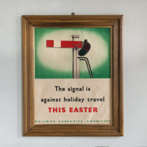
‘The signal is against holiday travel this Easter’
£420‘The signal is against holiday travel this Easter’
Born in Yarmouth, Reginald Mayes’ career began in the design studio of the Eastern Daily Press in Norwich. He moved to London where he designed water marks for paper manufacturers and studied life drawing at the Regent Street Polytechnic and Lithography under Gardiner, Clive. In the early 1930s he became chief staff artist at the London Midland and Scottish Railway public relations department, designing leaflets and posters. In the Second World War, Mayes produced a wide range of anti-travel and propaganda posters for the Railway Executive Committee. They discouraged railway travel with some humorous slogans such as ‘The signal is against holiday travel this Easter’. After the war he did freelance work before retiring to Kent where he relaxed painting landscapes.£420